Real-Time Locating Systems (RTLS)
What is Real-Time Locating System (RTLS)?
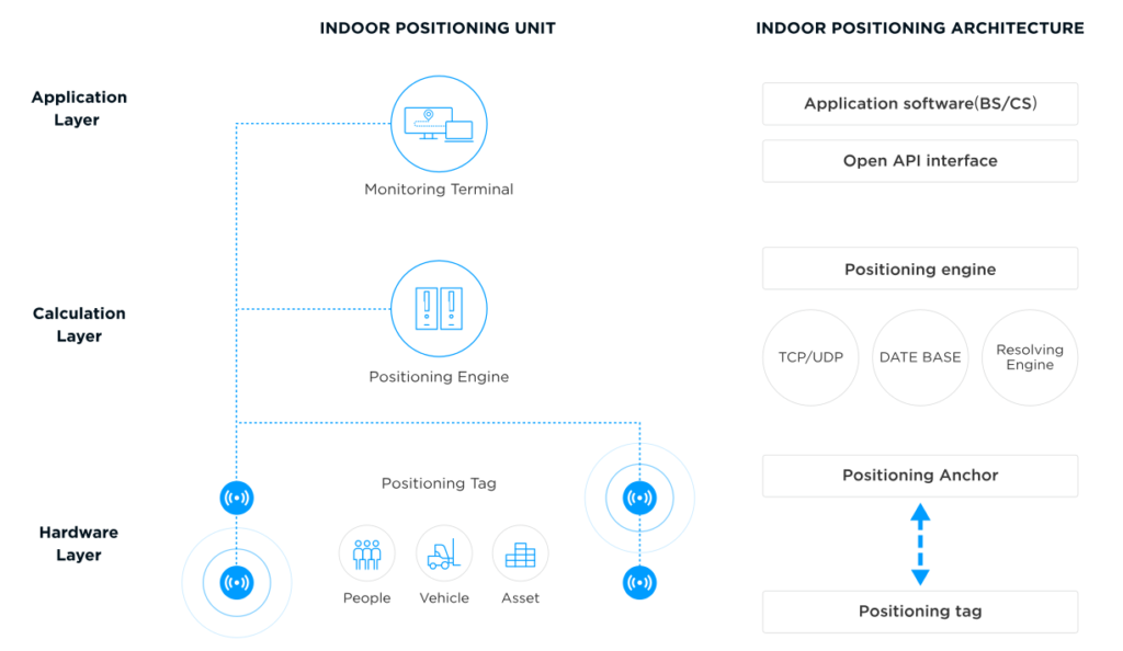
- Tags: These are small electronic devices attached to the assets or individuals being tracked. They emit signals containing their unique identifier.
- Anchors/Readers/Locators: These are fixed reference points strategically placed within the tracking environment. They receive signals from the tags.
- Location Engine/Server: This is the central processing unit that receives the data from the anchors, processes it using specific algorithms, and calculates the real-time location of the tags.
- Network Infrastructure: This facilitates communication between the tags, anchors, and the location engine. It can be wired (Ethernet) or wireless (Wi-Fi, Bluetooth, etc.).
- Software Application/User Interface: This provides a visual representation of the tracked entities’ locations, historical data, and often includes features for alerts, reporting, and analytics.
Different Technologies Available for RTLS
- Radio Frequency Identification (RFID)
- Passive RFID: Tags are powered by the reader’s electromagnetic field and have a limited range (typically a few meters). Primarily used for presence detection and less for precise locationing.
- Active RFID: Tags have their own power source, enabling longer read ranges (tens to hundreds of meters) and the ability to transmit signals periodically. Can achieve room-level accuracy.
- Ultra-Wideband (UWB): UWB utilizes short-duration, low-power radio pulses across a wide frequency spectrum. This allows for highly accurate locationing (centimeter-level) due to its excellent time-of-flight (ToF) measurement capabilities and resistance to multipath fading. However, it can be more expensive to deploy and has a shorter range compared to some other technologies.
- Bluetooth Low Energy (BLE): BLE is a low-power wireless communication protocol widely used in various applications. For RTLS, BLE can leverage Received Signal Strength Indication (RSSI) for proximity-based locationing (meter-level accuracy). More recently, the introduction of Angle-of-Arrival (AoA) and Angle-of-Departure (AoD) capabilities significantly enhances its accuracy (sub-meter level).
- Wi-Fi: Existing Wi-Fi infrastructure can be leveraged for RTLS using techniques like RSSI fingerprinting or Time-of-Arrival (ToA). Accuracy typically ranges from a few meters to room-level. It offers good scalability and coverage in environments with existing Wi-Fi networks.
- Infrared (IR): IR-based RTLS provides high accuracy within a limited line-of-sight range. It is often used in indoor environments where direct visibility between tags and sensors can be ensured. Susceptible to obstructions.
- Global Positioning System (GPS) and other Global Navigation Satellite Systems (GNSS): Primarily used for outdoor tracking, GPS offers meter-level accuracy. Not suitable for indoor environments due to signal attenuation.
- Magnetic Positioning: Utilizes the Earth’s magnetic field or artificially generated magnetic fields to determine location. Can work indoors but is susceptible to magnetic interference.
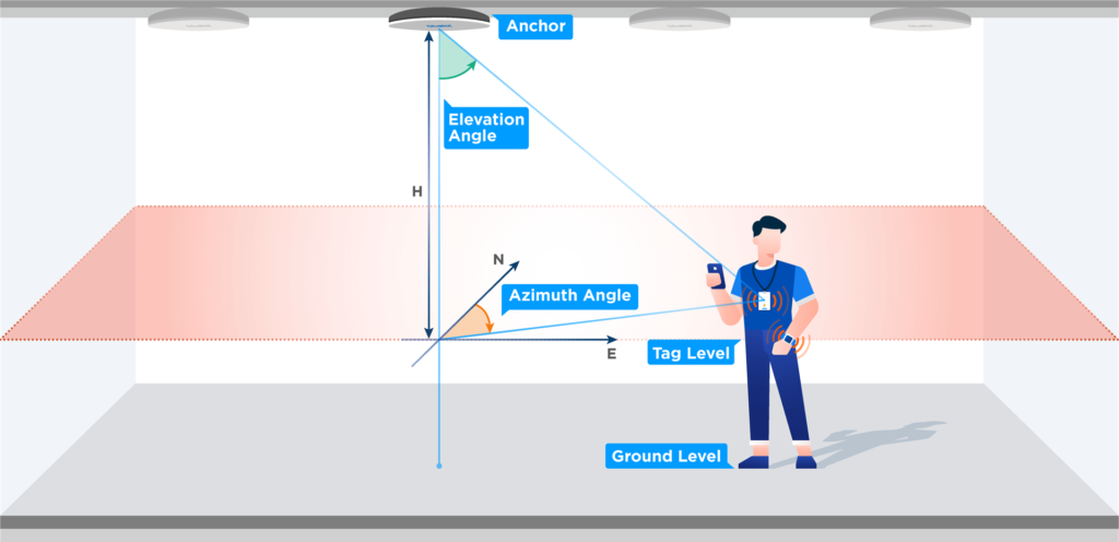
How Bluetooth Angle-of-Arrival (AoA) Works
- Tag Transmission: A Bluetooth tag transmits a special Constant Tone Extension (CTE) signal. This signal is designed to facilitate accurate phase difference measurements at the receiving end.
- Anchor Reception with Antenna Array: A Bluetooth anchor equipped with an array of multiple antennas receives the CTE signal from the tag. The physical separation between these antennas causes the signal to arrive at each antenna at slightly different times, resulting in phase differences.
- Phase Difference Measurement: The anchor measures the phase difference of the received signal across its antenna array. Sophisticated algorithms analyze these phase differences.
- Angle Calculation: Based on the measured phase differences and the known geometry of the antenna array, the anchor calculates the angle from which the signal originated (the angle of arrival).
- Location Determination: The calculated AoA from multiple anchors (at least two for 2D positioning and three for 3D positioning) can be used to triangulate the location of the tag. The intersection of the lines-of-bearing from each anchor pinpoints the tag’s position. This can be further enhanced by combining AoA with other information like RSSI or TDoA for improved accuracy and robustness.
Comparison of Bluetooth AoA with Other RTLS Technologies
| Feature | Bluetooth AoA | UWB | Wi-Fi RSSI Fingerprinting | Active RFID |
|---|---|---|---|---|
| Accuracy | Sub-meter (typically 0.1-0.3m) | Centimeter-level | Meter-level (2-5m typically) | Room-level (1-3m typically) |
| Range | Medium (up to ~100m, environment dependent) | Short-Medium (up to ~50-70m) | Medium-Long (coverage of Wi-Fi network) | Long (up to ~100m) |
| Cost | Medium (increasingly cost-effective) | High | Low (leverages existing infrastructure) | Medium |
| Power Consumption | Low (especially for tags) | Moderate | Moderate (for continuous scanning) | Moderate (for active tags) |
| Infrastructure | Requires dedicated AoA-enabled anchors | Requires dedicated UWB anchors | Leverages existing Wi-Fi APs, but fingerprinting requires initial mapping | Requires dedicated readers/anchors |
| Multipath Resistance | Good | Excellent | Moderate | Moderate |
| Scalability | Good | Good | Good | Good |
| Complexity | Moderate (complex algorithms for AoA) | High (complex signal processing) | Low-Medium (site survey required) | Low-Medium |
| Deployment | Relatively straightforward | Can be complex due to precise timing requirements | Relatively easy if Wi-Fi is present | Relatively straightforward |
Key Takeaways from the Comparison
- Accuracy vs. Cost: UWB offers the highest accuracy but comes with a higher cost. Bluetooth AoA strikes a good balance between accuracy and cost-effectiveness. Wi-Fi fingerprinting is cost-effective but less accurate. Active RFID offers a longer range but lower accuracy than AoA and UWB.
- Infrastructure Dependency: Wi-Fi fingerprinting can leverage existing infrastructure, reducing initial deployment costs. Other technologies require dedicated hardware.
- Power Considerations: BLE, including AoA implementations, generally offers lower power consumption for tags, which is crucial for battery-operated devices.
- Multipath Effects: UWB is highly resistant to multipath interference, which can degrade the accuracy of other RF-based systems. AoA is also relatively robust to multipath compared to RSSI-based methods.

Healthcare
- Asset Tracking: Locating critical medical equipment (e.g., infusion pumps, ventilators) quickly, reducing search times and improving staff efficiency.
- Patient Tracking: Monitoring patient movement within a facility for safety, workflow optimization, and contact tracing.
- Staff Safety: Enabling duress alerts for staff in case of emergencies.
- Inventory Management: Tracking medications and supplies to prevent stockouts and reduce waste.

Manufacturing
- Work-in-Progress (WIP) Tracking: Monitoring the location and flow of parts and assemblies through the production process.
- Tool and Equipment Tracking: Locating expensive tools and equipment, minimizing loss and improving utilization.
- Personnel Safety: Monitoring the location of workers in hazardous environments and ensuring adherence to safety protocols.
- Automated Guided Vehicle (AGV) Navigation: Providing precise positioning for autonomous material handling systems.

Logistics and Supply Chain
- Warehouse Management: Tracking the location of pallets, forklifts, and personnel within a warehouse for efficient inventory management and order fulfillment.
- Yard Management: Monitoring the location of trailers and containers in shipping yards.
- Cold Chain Monitoring: Tracking the location and environmental conditions of temperature-sensitive goods.

Retail
- Asset Protection: Preventing theft of high-value merchandise.
- Customer Flow Analysis: Understanding shopper movement patterns to optimize store layout and product placement.
- Inventory Management: Real-time tracking of stock levels on the sales floor and in backrooms.
- Personalized Customer Experience: Location-based services offering targeted promotions or assistance.

Construction
- Equipment Tracking: Locating heavy machinery and tools on construction sites.
- Worker Safety: Monitoring the location of personnel in potentially dangerous areas.
- Material Management: Tracking the delivery and location of construction materials.

Office Environments
- Meeting Room Management: Optimizing the use of meeting spaces based on occupancy data.
- Asset Tracking: Locating shared resources like laptops and projectors.
- Space Utilization Analysis: Understanding how office space is being used to inform future design decisions.

Security and Access Control
- Real-time Personnel Location: Monitoring the location of security personnel.
- Zoned Access Control: Ensuring that only authorized personnel can access specific areas.
- Emergency Response: Quickly locating personnel during emergencies.